The avalanche conditions around Xmas were pretty bad leaving us with valley bottoms as the only safe place to play in the snow. The night before, we were looking at the map and thinking that we might go to the base of Black Prince Cirque but stop there due to avi probability. We didn't go there but that day, the upper slope of Black Prince went class 3. It would have been cool to see it but predicting the danger was reassuring.
Instead we parked at the Lower Kananaskis Lake lot and marched north in a pleasant quarter day loop. Sandwiches and a thermos of coffee rounded out the day. Crossing the lake with massive gusts of snowy wind added just enough "I'm lost at the north pole" to make the coffee more enjoyable.
-Suz sprints up a hill
Opal range makes a pleasing backdrop
Wednesday, April 1, 2009
Tuesday, March 24, 2009
Mt Allan
At the time of posting, its now technically springtime which means I must finish off trip reports as the climbing season begins anew. The last trip of 08 was a solo trip I did up to Mt Allan in the Kananaskis corridor. At left is my route in google earth along with a ruler made of 14 Bessborough hotels for scale comparison for Saskatoon readers.
The trip starts off the #40 at the Ribbon Creek day use area and follows a network of switchbacking ski trails and goat tracks. After negotiating the maze the trail emerges from the trees and starts a pretty steep and relentless pitch following the ridge to Olympic summit.
Taking a breather on the ridge crest looking towards the north.
After gaining a thousand meters in elevation, the winds picked up made being exposed on the edge of a knife blade ridge rather unpleasant. I ran into two guys beating a retreat from the summit of Allan who reported wind snow and cloud. And so rather than fight for elevation only to be socked in with no view, I enjoyed the summit of Olympic and left the high traverse to Mt Allan for better weather.
View from Olympic summit south to Mt Kidd and the ribbon Creek valley.
Monday, January 12, 2009
Opal Ridge South
Made this attempt on Opal Ridge back in October 08. Opal ridge is the eastern wall that forms the north half of the Kananaskis valley. Its characteristic razor sharp ridge line makes it easily identifiable. Apart from the view down the Kananaskis corridor, one of the selling points of this trip is you can park your car at the gas station and treat yourself to a hot coffee and an Eatmore if you feel you deserve it.
Pic above shows route from gas station following power line and up north side of gully
View looking south from atop first set of shale cliffs. Topography forms huge wind funnel.
Looking west over highway 40 towards Mt Inflexible.
The wind steadily increased until it reached a force that made stable footing difficult. I shot this short video on a flat terrace where I hid on the lee side of a rock. Without that windbreak I would have easily been blown right off the slope. For those unfamiliar with high alpine trees, they're as stiff as metal and the fact that you can see them moving indicates a hurricane force wind. Video best viewed with sound to appreciate the force of the wind!
It became obvious that the wind was not going to allow me to continue safely so I made a retreat, down-climbing short cliff bands in between the huge gusts that made my heart pound pretty fast. Even the drive out of the valley was pretty sketchy with the car getting hammered by cross gusts. This route has some fun climbing and the views at the top that I didn't get to enjoy all conspire to ensure a return trip in 09.
Friday, December 19, 2008
Rae Glacier
From the Kananaskis valley, the Elbow valley always beckons us. Guarded by the raw and imposing Mt El Pocca and Mt Arethusa this valley has always been a brief glimps on the way by to somewhere else. At left I've drawn our route from the hiway to the glacier.
As we drove through Kananaskis valley, the clouds and fog were lifting as a new system blasted in. But for an hour, the mountains were half bathed in fog making some super views.
On this particular snowy day in October, we parked at the Elbow day use parking lot 6400ft and hiked in to Elbow lake. On the shore of the lake we met a couple backcountry skiers who had been tele-skiing on the glacier that morning. After getting the ski report we braved the increasing winds and snow as we hiked up the river to Rae Glacier which feeds the Elbow River and is the source of Calgary's water. At left, Suz pauses in the glacial deathscape, a desolate environment made more harsh by the 60km/hr wind stripping us of our comfort. But undeterred, we plodded through the snow to the glacier's toe before retreating to the valley.
As cold and miserable as it was, this was a good advertisement for the Elbow Valley. In the two pictures below, it is pretty easy to imagine a beautiful summer day following the river round the next turn and scrambling up the lofty peaks that rise above the valley. We'll definitely return here either as a multi-day trip through Pipestone Pass directly behind me in the pic, or to scramble part of Mt. El Pocca.
Yamnuska
I'm glad I've been lazy in recording our previous trips as these pictures are warming me up from the -40 its been lately.
On this Sunday afternoon in October, we thought we'd amble up Mt Laurie otherwise locally known as Yamnuska (translates to "wall of stone") For interest I proposed we tackle the south side rather than the normal approach from the northeast.
Here Suz stops to drink in a hard earned view of the Bow valley. Due to the loose condition of the rock, it was prudent to climb parallel routes. I recall having a similar sensation when I'm standing in line at the grocery store. "Is she on a better line than me? Should I snake in over there?" In the picture below, Suz is thinking about her next move.
eventually, the slabs turned into very loose scree. When loose scree is steep, climbing it can be like slogging on a stationary treadmill. I quickly realized why nobody goes this way! After a brief conference, we decided that swimming in this ankle-busting pitch was not enjoyable, we made our way down back into the trees where we promptly got misplaced. The emotions that accompany being lost are directly related to the weather, and this being a wonderfull day, we just enjoyed bushwacking through the trees. as we stumbled along, I caught some movement out of the corner of my eye and quickly directed Suz to some deadfall with a fisher on it! They're quite rare and you have to spend a long time in the bush to be lucky enough to see one. This one regarded us like a tom cat would sitting on a front porch, not really paying attention to us, but not exactly ignoring us either. We walked slowly to it as it half bounced and half slithered away in a very feline way. A vicious member of the weasel/wolverine bloodline, its one of the only animals that kills porcupines.
With all the time I spend in the bush, I've only ever seen one from afar and felt lucky at that. Our boneheaded route made us turn around and get slightly lost in the valley and ultimately rewarded us with this rare sight. Another endorsement of the path less travelled!
Wednesday, November 26, 2008
Buller Pass/Ribbon Lake
elevation gain 3000ft roundtrip 20km
Trip dates: Oct 2(snowline@ pass) and Oct 13/14(snowline @ hi-way)
I first hiked up to this pass in the first week of October to recon it for a longer backpack trip later that month. The trip begins like so many others at the shore of Spray Lake and climbs up between Mt Buller and Mt Engandine. You are quickly launched into the alpine zone and at this time of year, treated to a buffet of golden larches.
a river of larches draw you up to the valley
Looking back down the valley through the apocalyptic scenery. The bowl here is massive , creating a disorienting visual field. As I plodded through here, point release avalanches were shedding rocks so vigorously that it sounded like a bowling alley with a constant overlapping echoing of tumbling rock. Yet with all this activity, the walls were so deceivingly far that I couldn't see any falling rock.
click on this picture for a better sense of scale
----------------------------------------------------------------------------------------------------------------
Two weeks and much snowfall later, my friend Jim and I climbed up Buller and down into the Ribbon Lake valley system. I was quite glad I poked around this valley before the snow fell so I had a bit of a clue of the topography. It was amazing to see how a blanket of snow changes the mood of the mountains. Certainly the day I first went it was a cold fall day but with a couple feet of snow and without the comfort of seeing scrubby grass or other signs of life, this landscape went from austere to misanthropic. When the sun is shining and you're standing at the top, its easy to enjoy the surroundings. But when the clouds roll in and the snow begins to blow, one can easily anthropomorphize the weather's intentions.
This is a great day trip to the pass and back but camping on the other side opens up routes to hike out Ribbon valley or Guin pass back to hiway 40 for a great multiday hike.
Trip dates: Oct 2(snowline@ pass) and Oct 13/14(snowline @ hi-way)
I first hiked up to this pass in the first week of October to recon it for a longer backpack trip later that month. The trip begins like so many others at the shore of Spray Lake and climbs up between Mt Buller and Mt Engandine. You are quickly launched into the alpine zone and at this time of year, treated to a buffet of golden larches.
a river of larches draw you up to the valley
Looking back down the valley through the apocalyptic scenery. The bowl here is massive , creating a disorienting visual field. As I plodded through here, point release avalanches were shedding rocks so vigorously that it sounded like a bowling alley with a constant overlapping echoing of tumbling rock. Yet with all this activity, the walls were so deceivingly far that I couldn't see any falling rock.
click on this picture for a better sense of scale
----------------------------------------------------------------------------------------------------------------
Two weeks and much snowfall later, my friend Jim and I climbed up Buller and down into the Ribbon Lake valley system. I was quite glad I poked around this valley before the snow fell so I had a bit of a clue of the topography. It was amazing to see how a blanket of snow changes the mood of the mountains. Certainly the day I first went it was a cold fall day but with a couple feet of snow and without the comfort of seeing scrubby grass or other signs of life, this landscape went from austere to misanthropic. When the sun is shining and you're standing at the top, its easy to enjoy the surroundings. But when the clouds roll in and the snow begins to blow, one can easily anthropomorphize the weather's intentions.
This is a great day trip to the pass and back but camping on the other side opens up routes to hike out Ribbon valley or Guin pass back to hiway 40 for a great multiday hike.
Thursday, October 2, 2008
Pocaterra!
trailhead 7239 ft 1st mountain 8758 ft total 9.3km
Pocaterra ridge is the finest hike we've ever done. The trail meanders past golden larches into sculpted cirques, through meadows, to lofty vistas. This has it all including a fitness test of a mountain to ascend before carrying on tip-toes across a knife-blade ridge that finally cured my vertigo.
We chose to do this as a car shuttle with Nolah and Carrie parking one car at the foot of Gap Peak and the other car at Highwood pass where we started. At left is the west half of Pocaterra ridge including a rather hair-raising traverse below the crest of the mountain at center.
Here Suz and Nolah throw their backs into the first big ascent. We shared this slope with a few mountain sheep that were pretty casual about us. I enjoy the view of Gap Peak and El Poca seen behind me.
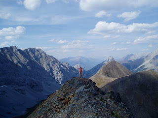
Below is the view from the north peak. We scrambled atop the crest of this ridge trying not to look down either side too much.
Here, Suz reacts to her position in the world. This spot may be my favorite square foot to stand on in Canada. Nolah carefully negotiates a downclimb below the summit. This was a pretty intimidating spot owing to its position a thousand feet above the valley floor. As with many things in the mountains though, they look much scarier from afar and when you're right there, the way is more straightforward.
I'm still amazed at the ease that her dog Sophie made it through here!
In this picture I've drawn our route in light blue, it probably needs to be clicked on to see the detail. Going at a fairly casual pace, it took us 6 and a half hours for the complete traverse. We give this trip our highest rating possible owing to its spectacular scenery and proud sense of accomplishment. We were constantly looking back where we had just come from and being very impressed with ourselves. Though not difficult, being perched atop very narrow sections and knifing along very high cliff faces does test the nerves.
Subscribe to:
Posts (Atom)