Sunday, September 28, 2008

Mt Cory / Cory Pass


Mt Cory, seen on the left has always been on my list. It has 3 big ribs that are rather interesting, the leftest (east) being the ascent route. Technically, its considered easy peak.


The first bit of this climb is usually referred to as "shaley cliffs." I would rather call it "ball bearing like marbles miraculously hovering over slippery cliff bands." Anyway, by myself, it seemed foolhardy to be clinging and slipping over this stuff so I morosely came back down and headed up the col that connects Mt Cory to Mt Edith.


A picture of me making up my mind about the slippery cliffs and a view from Mt Cory of Mt Rundle,


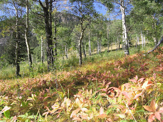
The path to the pass is wonderful at lower elevations as it passes through open meadows and groves of aspen sprinkled with ancient douglas fir. It looks like a scene from a cowboy movie though I didn't run into anyone whose name may have been Hoss.


As the trail climbs out of the meadows, it rises at a steep and unrelenting pace with rewarding views of the valley below. As a second prize trip that day, it was fantastic. In fall, the first half hour of Cory Pass is a must do for its almost cliched pastoral beauty.


click on this panorama of the valley for a better sense of the view from just halfway up.

Thursday, September 25, 2008

West Wind Pass

trailhead 5600 ft pass 6888 ft elevation gain 1290 ft round trip 6km


Have you ever opened up the fridge and looked at that can of ice creme sauce, you know the chocolate syrup in the yellow can, and just taken a big spoon and gulped a massive dollop?


That's kind of what the West Wind Pass is like. In one hour you go from standing around the tranquil shore of Spray Lake to the chocolaty delicious heights of the Windtower overlooking both the Spray valley and Bow valley. In terms of hiking effort, this is the easy desert lurking in the fridge.


Spray Lake and Mt Engadine behind me.


West Wind was not named by the same people that named Greenland and in this picture. my hair looks like its in a wind tunnel! We found a spot just under the overhang behind me to have lunch and eyeball the route to Pigeon mountain, a future trip.


After a brief lunch, we scrambled up the shoulder of The Windtower for a better view of Spray Lake. After this short reconnoiter, this peak has made it on next years list of peaks to climb.


It seems like our favorite hike is always the last one we do! Certainly for a late start, short drive, and quick catapult into the sub alpine, this hike has lots to offer. Our rating: 8.5 dollops of chocolate syrup out of 10

Monday, September 22, 2008

Mt Bourgeau

trailhead 4596 ft Harvey pass 8025 ft round trip 19.2km elevation gain 3431 ft


When a couple of Suz's friends from England passed through our neck of the woods, Suz offered to take them out on a hike in Banff. Mt Bourgeau is just a few kilometers west of Banff so off we went to check it out. If we hadn't been visiting, we probably would have become impatient with the longish trudge through the trees.


This chore done with though, the trail opens up to the sub alpine where waterfalls are switchbacked and cliffs soar above. Bourgeau Lake is typically pristine as most mountain lakes tend to be. Upon gaining the upper bowl, you are treated to grassy ledges, trickling creeks and rocky, rolling decorations. These alpine meadows always make me feel like a dog suddenly off leash trying to run in three directions at the same time.

With a little more effort, we wandered up further to reach Harvey pass. The picture below is looking north from the pass. Somehow the rest of our pictures got erased while we were in Newfoundland (I blame the time change.)


Harvey pass is the start of the climb up Mt Bourgeau. At this point we turned around as we had a very leisurely coffee in Banff to start the day. Next Year I guess. On descent, our blue skies quickly turned afoul and a cold rain pounded us for hours as we retreated. I had played raincoat roulette that day and left my raincoat in the car. Not thinking it was a big deal since we were on an easy trail, I paid the price and got well deserved ribbing from Suz.

Middle Sister

trailhead 4380 ft summit 9085 ft roundtrip 20.4km elevation gain 4704 ft


Since Middle Sister is part of the canon of Bow valley summits I would be remiss without an attempt. Left to right in the picture below:


Little Sister is a rock climbing pitch, Middle Sister is a scramble and Big Sister is an alpine climb. The route, shown above is a long trudge up Stewart creek starting on the outskirts of the Canmore Golf Course. Stewart creek eventually becomes a rocky, dry bed of boulders and dry waterfalls that emerge several kms later in a bowl connecting the Three Sisters to the Rimwall. Great views of the cliffs and the Bow valley greet you as you make your way up. On this particular trip, I packed it in at the Col connecting Middle Sister from Big Sister or the right-hand saddle in the photo. I was really too tired to be in the mountains even though I was tantalizingly close to the summit, but I will certainly come back here to finish this one off.

Thursday, September 18, 2008

Sparrowhawk Tarns

trailhead 5642 ft. upper tarns 7872 ft. total elevation gain 2230 ft 10 km return

Our tried and true hiking bible proclaimed that "surely there are Orcs hiding in the rocks here" and we can testify that this valley is the most Tolkeinesque we've seen. The trail begins on the Smith-Dorien road on the shore of Spray Lake and climbs between Mt Bogart and Mt Sparrowhawk which I attempted last fall. The trail follows a babbling brook then disappears into a huge rockslide. One navigates through boulders ranging from house to car to appliance sized all under the eaves of heavily castelleated cliffs that look almost like eroded palaces.


In the upper bowl, a colony of marmots sunned themselves and pawed at the rubble looking for grubs and other yummies. They pay little attention to us and so we got within a fluffy tail length of them.


At the top of the cirque above the trees, at Mt Bogart's side are the glacial fed tarns or small lakes. Each one the size of a large swimming pool, and all on different grassy terraces flowing into one another as though we were in the back yard of a wealthy giant. Lichen covered rocks split the scenery up into flowing rooms that are wonderful to roam through allowing a different tableau at every turn.
In the picture, Suz makes her way through the rockslide with Spray Lake in the background. I'm pausing with part of Mt Sparrowhawk rising behind me to the right. Having it loom over us all day made me want to return to have a successful summit there to make up for last years retreat.

All told we loved this hike and give our highest rating to date: 9 out of 10

Mt Grotto


After finishing work for the summer, I wanted to hit the slopes while I still had my bush legs so while Suz was hard at work I climbed Mt Grotto via the ACC direct route (the yellow line in the photo.) I made the 8881 foot summit in 2 hours and 30 minutes, a time that I will not likely ever break. The weather just cleared in time to present me with a rainbow over the Bow river, but the wind was howling so hard I had to stuff kleenex in my ears to keep my head from pounding. In the pictures below left,the town of Canmore and on the right is the front ranges marching southwards. This trip is more of an accomplishment than a pleasant journey but it was a good welcome back to the mountains of home.

A rare weekend roam while at work

During the summer Suz came out to visit me in Kananaskis while I was at work. I did some lighter duty work so she could walk around with me all day which was pretty fun. We looked at some clearcuts and some reforestation. Here's Suz delivering her "stump speech" take note hopeful MPs, this is how you do on-the-job- photo-ops!


This last picture is from my helicopter, its a shot of the Martin Hills at sunset. The leaves are all green but they were reflecting scorching red as the sun set. Part of a circular rainbow can also be seen, one of the rare joys of flying around all day.

Wednesday, September 17, 2008

Feb winter activities


Got lazy with updates. Must get last winter's stuff on here before it snows! Too late, it snowed in Canmore already. Anyway here comes a torrent of updates:


We XC 'd the spray River trail starting from the Historic Banff Springs Hotel and meandering down the valley towards Spray Lakes. It was a triffle warm but any time you can get a sunburn in the winter is a good day methinks. Its an easy trail with some long glides and great scenery a mere double pole from downtown.
____________________________________________________________________

Johnson Canyon is swell trip made better if you can go when there are no tourists. Winter we thought might be just such a time. So we donned the spikes and headed up the canyon. Its a wonderland in the winter with massive curtains of icicles and the frozen river makes access to nooks and crannies much easier.

In the pics, Suz walks right up to the frozen torrent that normally one sees from high above behind a railing. At the upper falls a team of ice climbers studies a route.

____________________________________________________________________


Another crowded spot that winter emptied for us was Lake Minnewanka, on Banff's outskirts at the eastern flank of Cascade mountain. There we found some curious ice formations, pressure fractures piling up against the rocky shoreline.
Along with our friend Jim, we moseyed along the lake down to Stewart creek which we followed for several kms. The snow depth finally turned us back

As beautiful as this lake is, it has seen its share of grizzly events. There's been a few cougar attacks here and Aylmer pass leading out the north side is often closed because of heavy bear density. This lake is a popular trail to cycle around in the summer but winter is a great time to visit the places usually crowded in the summer.


____________________________________________________________________

For minimal effort and a great reward, Stony Squaw Mountain is an easy outing. The trail starts at Mt Norquay and rumbles up a several hundred feet to the top yielding a great view of the Bow corridor and Banff. Again, I can only assume that this trail is crawling with people in the summer, but then again, the summer crowds seem to be pretty predictable in their reluctance to get off too far from the pavement. Not much snow had fallen recently and we didn't even need snowshoes to get to the top.

We did a few other ski trips that muddle now in my mind 8 months later! Had some great powder days alpine skiing though pictures would mostly be white!

In this pic, snow piles up in the Louise backcountry

I had one very trying experience traversing Louise's back bowl in a total whiteout. The snow was deep and fluffy enough, and visibility was so bad that I honestly could not tell if I was moving or not. A strange sensory deprivation. The picture above was one of those perfect days. I had this pitch to myself for the day.